Kazakhstan Mountains
Passes and Mountains of Kazakhstan regions. Kazakhstan waterfalls
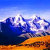 |
Belukha Mountain Belukha Mountain is in the north-east, with a snow-capped peak (4,506m) - the highest in Siberia and the Altai. This is a kingdom of snow, ice, roaring avalanches and sparkling waterfalls. Its neighbor, Mount Berkutaul (Eagle's Nest), altitude 3,373m., is the second most popular peak of the Southern Altai .... |
|
 |
Burkhatskiy Pass The route to Burkhat Pass (the place where the conditional border of Asian and Siberian animal life is located). Austrian-built road. Entry to Katon-Karagaisky State National Nature Park. Austrian road: The length of this section of road is 50 km (5 hours' journey), from Marcacol Lake to Burkhat Pass. Quality - gravel mountain road difficult to traverse ... |
|
 |
Karatau Mountains One very interesting attraction for travelers is the modest mountain peak Kazigurt (1,775 m) located 40 km to the south of Shymkent. With this lonely mountain massif the local population has connected many legends. In particular, it is believed that Kazigurt is the resting place of Noah's ark, evidence of which is the glade Keme-Kalgan, having the shape of a ship bottom at the top of the mountain ... |
|
 |
Kazygurt Holy Mount Holy scriptures (Zabur, Taurat, Inzhil, and the Koran) contain a myth about a righteous person named Nukhepaigambar (Noah in Christianity). In an epochal act he saved himself, his whole family and fauna specimens from the Flood. Warned by the Lord, he constructed an enormous ark (kerne) where he placed "a pair of each animal" ... |
|
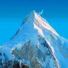 |
Khan Tengri Mountain Khan-Tengri ("Lord of the Spirits") is considered one of the most beautiful peaks of the central Tien-Shan. A picture-perfect pointed pyramid, it can be seen from almost everywhere. The mountain has long been wreathed in legend. It is still called Tengritau (God's mountain) and Kantau (the bloody mountain), from the glow of the peak at sunset ... |
|
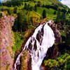 |
Kock-Kol waterfall The waterfall Kock-Kol is one of the largest mountain waterfalls in the Altai. There is no motorway access to this tourist destination (as well as the surrounding network of sights). You can approach these places on foot (trekking) or on horseback. The length of the route is 35 km (to the north of Rakhmanovskie Klyuchi) ... |
|
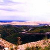 |
Mramorniy Pass - Chinese border We move northwards to the spurs of the Southern Altai. The road is asphalted, allowing us to drive comfortably at a speed of 40-60km/h. The road. Again we drive on the asphalted road which leads us to the high Altai mountains ... |
|
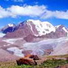 |
Talgar Peak The Talgar Peak (4,973m) , visible from Almaty, like a vengeful tooth, the highest peak in the Zailiy Alatau, located at a height of 4,973m above sea level, is higher than Mont Blanc. Its steep slopes are covered with glaciers, and snow fields stretch across its foothills ... |
|
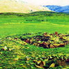 |
Ulytau The Ulytau is one of the most ancient mountain masses of the Sary-Arka, which runs north to south for 200 km. The highest point is Akmeshit Peak at 1,133m. The Ulytau are great mountains, they are the historical centre of the Kazakh people, the nomadic cultural epicenter of steppe civilization ... |
More useful links: